What is MaRTy?
MaRTy is a mobile biometeorological instrument platform that was designed to measure pedestrian thermal comfort. In other words, it is a weather device that measures the many factors that contribute to how hot it feels, especially during extreme heat events. Though we are most familiar with air temperature, there is another metric that plays an even bigger role in how hot it feels: mean radiant temperature (MRT). MRT is a metric that tells us the total heat load a person would experience in a given location based on the incoming radiation. To measure MRT, MaRTy has 3 net radiometers that measure radiation from 6 directions. The other meteorological conditions that MaRTy measures are the air temperature, humidity, wind speed and direction, plus the GPS coordinates. The ability to measure MRT on the ground without computer modeling is what makes MaRTy an incredibly useful tool (and is why its name is capitalized the way it is).
MaRTy was developed at Arizona State University in response to a lack of instrumentation that could accurately capture the thermal load—or total stress due to heat—on the human body. MRT is distinct from, though highly related to, the two most common metrics used to measure the Urban Heat Island Effect (UHI): air and land surface temperatures.
The UHI occurs when the average air and land surface temperatures are greater in urban areas than their proximate rural or undeveloped regions. The UHI can also appear within cities when some neighborhoods are measurably hotter than others. These increased temperatures are caused by less vegetation and more built materials that absorb heat like roads, parking lots, and buildings. In places with the UHI, nighttime air temperatures are higher because surfaces like asphalt absorb so much daytime heat that they do not fully cool at night. Land surface and air temperatures are useful metrics for large-scale urban heat mitigation plans, however, they have some critical limitations. To implement cooling solutions in cities that target improving the comfort of pedestrians, we must study urban heat on the hyper-local scale.
Neither land surface nor air temperature can tell us how hot the outdoor environment actually feels to people. Therefore, technical solutions that lower the land surface temperature often do not lower the “feels like" temperature to a person outside. MRT gives us better insight of the “feels like" temperature, which is critical for informing climate change adaptation strategies. Both urbanization and climate change are increasing the intensity of extreme heat events. We cannot control when we will have heat waves, but we can control how we build our cities, and urban planners have the ability to reduce the temperature that pedestrians experience during extreme heat events. MaRTy is a tool that informs us on how the built environment can exacerbate heat, the effectiveness of heat mitigation technologies and strategies, and the value of cool spaces on extremely hot days.
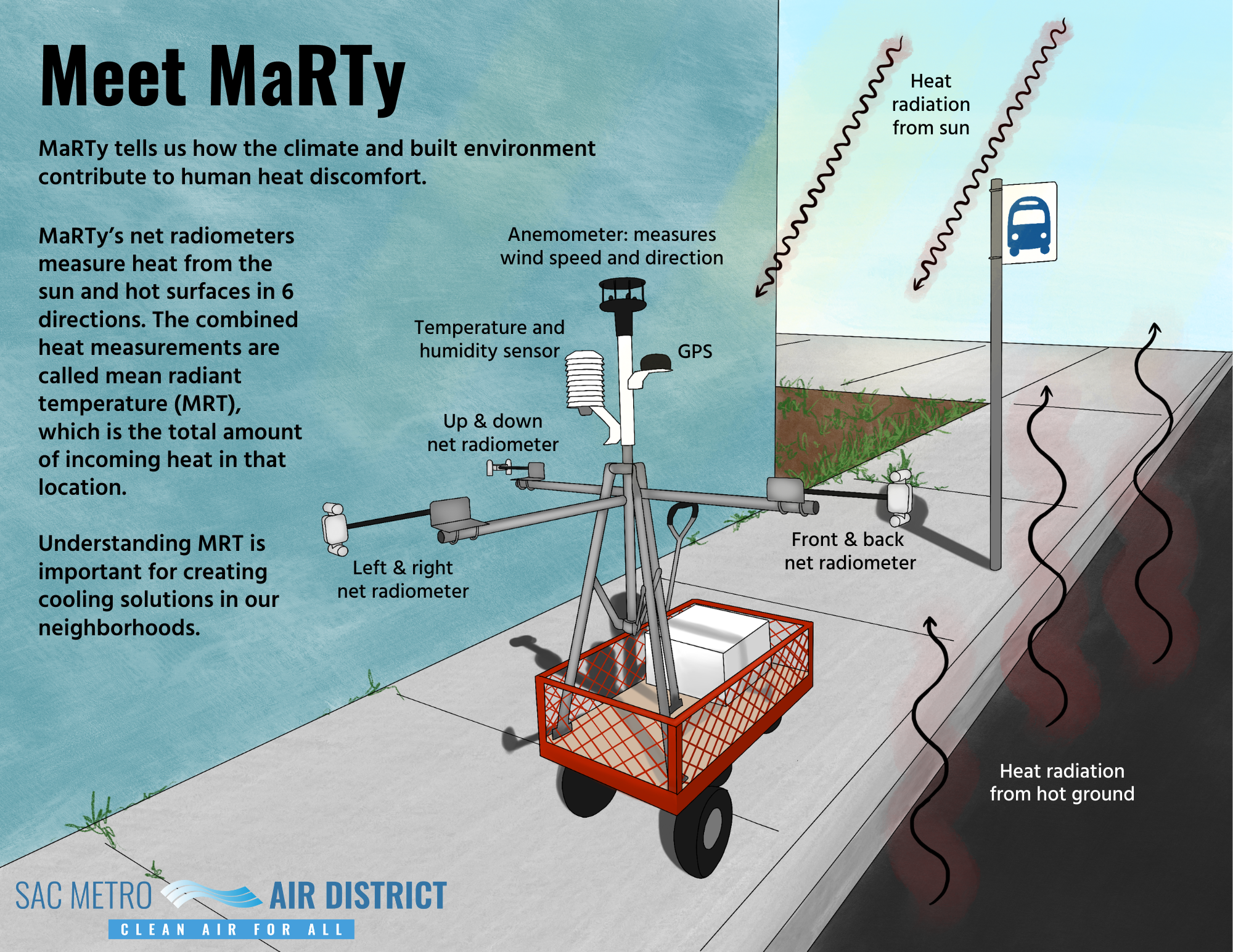 Illustration by Fiona McLaughlin
Review of Environmental Concepts
The goal of the Sac Metro Air District is for MaRTy to be useable for planners and policymakers who may not have a background in environmental science. MaRTy measures air temperature, relative humidity, wind speed, and radiative inputs. Below is an overview of the physical processes behind those measurements and how they contribute to human comfort.
Keywords
- Electromagnetic waves
- Radiation
- Shortwave radiation
- Longwave radiation
- Albedo
- Evapotranspiration
- Latent heat of evaporation
- Relative humidity
- Thermoregulate
- Convective cooling
Radiative Inputs


The sun emits electromagnetic waves, and they carry energy. Radiation is the transfer of heat energy by electromagnetic waves of different wavelengths.
MaRTy's sensors detect two forms of radiative input: shortwave and longwave. Distinguishing between the different wavelengths that add up to the total radiative input help inform the sources of the heat energy. In a nutshell, shortwave radiation (SW) is direct or reflected radiation from the sun, and longwave radiation (LW) is heat that has been absorbed and reemitted. As you can see from the chart, UV rays (ultraviolet) are a form of SW that you are probably already familiar with. This is the SW we are measuring. On the opposite end of the spectrum, infrared rays are a form of longwave radiation. This is what you feel radiating from a hot parking lot.
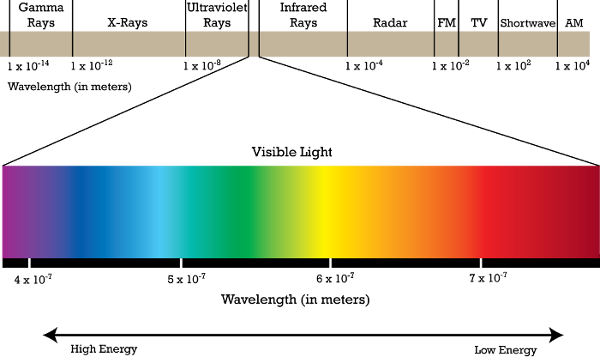
Photo credit: https://waves.neocities.org/spectrum.
Albedo refers to how much a surface reflects versus absorbs electromagnetic radiation, and it corresponds with how light or dark the surface is. Albedo is a fraction—the highest albedo equals 1 and the lowest equals 0. An albedo of 1 is pure white and reflects all incoming electromagnetic waves, whereas 0 is pure black and absorbs all electromagnetic waves. On a sunny day with the air temperature below freezing, snow does not melt despite intense incoming SW because its high albedo reflects radiation instead of absorbing it and heating up the snow. Unshaded asphalt parking lots get so hot because their low albedo causes them to absorb most of the incoming SW, heat up, and emit LW.
MaRTy measures SW and LW inputs coming from 6 directions through its 3 net radiometers: one up-down, one left-right, and one front-back. Sources of SW can include direct sunlight, reflective surfaces like windows, or materials with high albedo, and sources of LW are surfaces and building materials with low albedo. These radiative measurements used to calculate the mean radiant temperature (MRT).
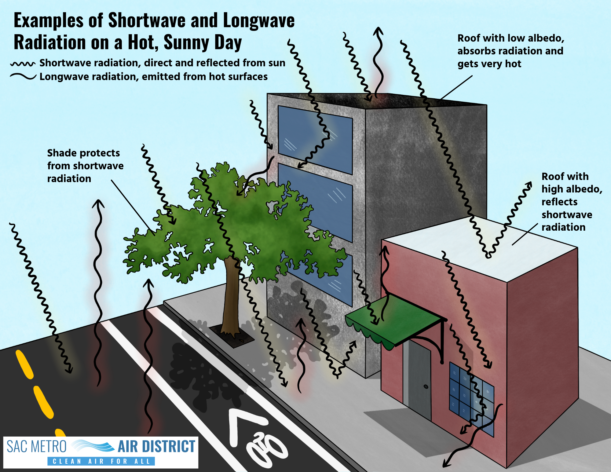 Illustration by Fiona McLaughlin
On a global scale, some incoming SW from the sun is reflected by high albedo surfaces like the polar ice caps and most of it is absorbed by the rest Earth's surface. This causes the Earth to emit large amounts of LW. Some of it is released into space, and some of it is absorbed by greenhouse gases and reemitted back to the Earth's surface, which keeps our atmosphere at a livable temperature. (The existence of greenhouse gases is a good thing—it is excessive emissions of greenhouse gases by humans that make our atmosphere too hot and cause climate change). Clouds both protect us from incoming SW from the sun and emit LW towards the Earth's surface. On the hottest days of the year in dry climates like Sacramento, it usually is not cloudy, and the main source of incoming radiation is SW from the sun. Because of this, it is important that it is sunny and cloudless on the days data is collected with MaRTy.
Air Temperature, Relative Humidity, and Windspeed
There are several reasons why air temperature measurements on a hyper-local scale can vary from site to site. It could be influenced by land surface temperature, which as discussed, is caused by the absorption and emission of radiation. Another important factor is evapotranspiration and the latent heat of evaporation.Evapotranspiration is the combined processes of transpiration and evaporation that move water from the ground into the air through plants. Transpiration is when plants pull water from the ground and release it through their leaves. The water then evaporates off the leaves and enters the atmosphere as water vapor. This phase change from liquid to gas requires energy. Heat is energy, so pulling energy from the surrounding atmosphere to complete the phase change pulls heat from the air. The result is that through evaporation, plants literally pull heat out of the air. The amount of energy it requires to evaporate, or the “lack of heat" caused by this process, is referred to as the latent heat of evaporation (LE). While MRT does not measure LE, understanding this process can explain why the air temperature is usually cooler around vegetation. In urban heat mitigation planning, there are many arguments towards the benefits of increasing vegetation, and this is one of the reasons why.
Due to the same process of LE, one way our bodies cool themselves is from the evaporation of sweat. How humid it is affects the ability of sweat to evaporate. The more water vapor that is already in the air, the harder it is for sweat to evaporate, and therefore calculating relative humidity (RH) is important for gauging the “feels like" temperature of a location. RH is measured by percentage, and it describes the amount of water vapor in a parcel of air compared to the maximum amount of water vapor it can hold. Even if the air temperature is the same, lower humidity feels cooler and higher humidity feels warmer. MaRTy is most accurate in dry climates like Arizona and Sacramento because RH usually doesn't play a large role in the “feels like" temperature.
Humans also thermoregulate (keep our body temperatures within certain boundaries despite the outside environment) through convection, or the movement of air. This makes wind speed another important measurement for the “feels like" temperature, because it contributes to convective cooling. Our bodies produce heat and emit radiation. When the air around us is still, a layer of air around our bodies is heated by the radiation we produce and keeps us warm. Wearing layers makes us warmer because it traps that radiated heat close to our bodies. Convective cooling removes the heated layer of air and replaces it with colder air. The stronger the wind speed, the more convective cooling occurs, which makes the air temperature feel colder. The wind chill in weather reports predicts how cold the temperature outside will feel when convective cooling is accounted for.
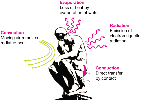
Photo credit: https://xaktly.com/HeatTransfer.html
How Does Mean Radiant Temperature Work?
Using MaRTy, MRT is calculated from the combination of radiative inputs from 6 directions to produce a measurement of the thermal heat load. This calculation is specific to the exact location where MaRTy stands, giving it the ability to capture fine-scale thermal variations between sites. In other words, MRT can distinguish the temperature differences that humans feel depending on a variety of factors, like how sunny or shady it is or how hot the ground beneath them is.
Though we feel a significant difference between the shade and the sun on a hot day, the air temperature might not change very much between the two locations. This is because air temperature is not measuring radiation, and incoming radiation has a very strong influence on the temperature that humans feel. For example, on a cold day, if the sun is shining on your skin, it will make your skin feel warm despite the low air temperature. By measuring incoming radiation from all directions, we are able to get a much more accurate picture of how much stress due to heat a person will experience in a specific location.
The air temperature, relative humidity, and wind speed are not a part of the MRT equation, but they are still important metrics to know because they affect our thermoregulation. While radiation is always the dominant factor influencing human comfort in a hot, dry climate like Sacramento, it is especially dominant on days with low windspeeds and relative humidity (which is typically the case on the hottest days of the year).
MRT is not a “feels like" temperature of the location—it is just measuring the factor that has the strongest influence on how the human body will thermoregulate. This is why we say MRT measures the “thermal heat load." Upon receiving the incoming heat load, the human body will thermoregulate in an attempt to feel more comfortable. A “feels like" temperature of a given location would account for this thermoregulation process, which differs drastically from person to person based on a variety of factors. MRT, the other metrics measured by MaRTy, and information from passersby collected by heat comfort surveys can be added to a heat index called the Physiologically Equivalent Temperature (PET) to give us an estimate of the “feels like" temperature based on the human body's thermoregulation process.
On its own, MRT cannot determine the relative radiation contributions from nearby surfaces and objects. MaRTy will give you a lower MRT value if you move it from the sun to the shade, but it cannot tell you that the change is due to the shade. In the existing MaRTy literature, MRT data is often combined with fisheye photos of the sky from each collection site or an urban modeling software that can make inferences on how the built environment produces the MRT reading.